Peishui 浿水 found. Wanggomsong 王儉城 of Old Choson 古朝鮮 and Pyongyangsong 平壤城 of Koguryo 高句麗 located at Gucheng 固城 of Dingxing 定興, Baoding 保定
카테고리 없음
Retracing the course of a stream which I suspected to be Peishui,
with my index finger on the screen all the way from its lower reaches upward,
my eyes fixated on the name label of a village on the satellite map,
and I nearly fell off the chair.
Introduction
The most effective method to search for an old place name, the location of which has long been lost, is to firstly find something in the vicinity that would not have moved or easily changed over time, such as a river, a mountain, etc., or in the case of a man-made entity, a wall 長城, a gateway 關門, or even another place name with a known, definite position, and then using it as the absolute reference point in relation to attributes of the place name in question, such as distance, direction, etc., that can be verified in records.
Wanggomsong 王儉城1 of Old Choson 古朝鮮 is not an exception in that a lot of effort has been put into the search for Peishui 浿水 firstly, which is known to have flowed in proximity to Wanggomsong.2 The search for Peishui is crucial not only due to the very fact that Wanggomsong was the capital of Old Choson, the first Korean state, but also in that along with the discovery of Wanggomsong the whereabouts of Koguyro(高句麗)'s Pyongyangsong 平壤城3, Parhae(渤海)'s Chunggyong Hyondokpu 中京顯徳府, as well as Nangnang 樂浪4 the Han 漢 commandery, would also be revealed, and further in that the results may lead to a new context for coordinates, which could enable in turn, the search for the subordinate prefectures of Nangnang, the fortresses of Koguryo, including Anshi 安市, Yodong 遼東5, Paegam 白巖, Hwando 丸都, etc., as well as Salsu 살수 薩水 the scene of great victory.
However, as with all aspects of study into Old Choson 古朝鮮, there is insufficient historical data, and even those which remain in fragments have problems such as mixed records diametrically contradicting each other, even regarding the basic characteristics of Peishui 浿水, for example, its direction of flow. Additionally, instances of records where another character had been used in place of '浿' of 'Peishui 浿水', which is similar phonetically or in appearance, have only lead to further confusion. Subsequently, the views each of which claim a different location for Peishui, were unlike by a long way without commonality, in consideration of which it would seem not unreasonable to contemplate that a critical point may have been reached in the endeavour to discover Wanggomsong 王儉城 via Peishui.

Based on the records contained in Book of Jin 晉書, over Qin 秦 and Han 漢 periods Donghu 東胡 populated the plains of Zimeng 紫䝉. According to dilizhi 地理志 in Book of Tang 唐書 there were frontier strongholds of Zimeng 紫䝉, Bailang 白狼, Changli 昌黎, etc., in Pingzhou 平州. They were all at the southern limits of Khitan 契丹, in the northern part of Pingzhou. 據晉書載記 秦漢之間 東胡邑于紫䝉之野 唐書地理志平州有紫䝉白狼昌黎等戍 盖平州之北境契丹之南界也
Zizhi Tongjian 資治通鑑 book 214, annotation by Hu Sanxing 胡三省
The writer of this article also did what little he could by investigating the existing research materials by others, as well as exploring original historical texts for new clues, albeit forced to stop at a deadend numerous times. Is Wanggomsong 王儉城, along with Peishui 浿水, ultimately destined to remain an unsolvable riddle forever? It was around the time when the efforts being made were looking to be in vain, the writer's persistence eventually paid off; an annotation verse to Zizhi Tongjian 資治通鑑 (See above) by Hu Sanxing 胡三省6 was captured in keyword searches over original texts. This writer immediately seized upon the seriousness of Hu's record, and subsequent pursuit based on the record as a vital clue resulted in the discovery of precise, absolute position for Peishui prefecture 浿水縣, and hence the true identity of Peishui. And at a location not far to the east of Peishui so discovered, the ruins of Wanggomsong became apparent right away.
Zimeng of Tang's Pingzhou at the border region between Khitan and Northern Song
Peishui 浿水 emerges from Loufang 鏤方 prefecture of Nangnang 樂浪, flowing southeastward past Linpei 臨浿 prefecture, before it enters the sea eastward. 浿水出樂浪鏤方縣 東南過臨浿縣 東入于海
Shuijing 水經, 'Peishui 浿水'
Pei 浿, the river emerges from Loufang prefecture 鏤方縣 and enters the sea eastward. It belongs to 'shui 水' category(部), and follows the sound of 'bei 貝'. Some say that it emerges from Peishui prefecture 浿水縣. It is read 'pai 普拜切'. 浿水出樂浪鏤方東入海 从水頁聲 一曰出浿水縣 普拜切
Shuowen Jiezi 説文解字, book 11 上
Zimeng prefecture 紫蒙縣 was originally Loufang prefecture 鏤方縣 of Han 漢. Later Funie state 拂涅國 established Dongpingfu 東平府 which had jurisdiction over Zimeng prefecture. Later it was relocated to Huangling prefecture 黄嶺縣, and incorporated into it. Parhae 渤海 reinstated Zimeng prefecture. It consists of 1,000 households. 紫蒙縣 本 漢 鏤方縣地 後 佛寧國 置 東平府 領 紫蒙縣 後徙 遼城 并入 黄嶺縣 渤海 復為 紫䝉縣 户一千
History of Liao 遼史 dilizhi 地理志, 'Dongjing Laioyangfu' 東京遼陽府'
In order to locate Peishui 浿水 one may firstly consider tracking down the prefectures of Peishui 浿水縣 and Loufang 鏤方縣 belonging to Nangnang 樂浪 commandery, which are recorded in historical literature as the sources of Peishui. Let us have a look at Loufang.
According to the records of Shuijing 水經 and History of Liao 遼史 dilizhi 地理志, Peishui 浿水 originated from Loufang prefecture 鏤方縣 of Han(漢)'s Nangnang 樂浪 commandery, where Liao 遼 state later established Zimeng prefecture 紫蒙縣. However, historical records in regard to Loufang, other than those that are already known through books such as Shuijing, are mostly just redundant material reiterated elsewhere, there being no further source which may be useful. We would have to count on Zimeng prefecture for which more material may have been preserved, even though so far there has been no known record that could determine its specific location, apart from the historical fact that Zimeng had been the stronghold of Donghu 東胡 during Qin 秦 and Han 漢 periods, and that Murong Hui 慕容廆 of Xianbei 鮮卑 had established the capital of his state there in 294 AD, through which it has been barely possible to suppose the existence of Zimeng somewhere in northern China. Then recently, this writer has uncovered a new record which had been buried and hidden all this time until now, enabling us to significantly narrow down the scope of investigation to track down the precise location of Zimeng. The aforementioned annotation to Zizhi Tongjian 資治通鑑 by Hu Sanxing is exactly the record newly discovered. Let us examine Hu Sanxing's record along with the original texts from Book of Jin 晉書 and New book of Tang 新唐書 dilizhi 地理志 quoted by Hu.
Based on the records contained in Book of Jin 晉書, over Qin 秦 and Han 漢 periods Donghu 東胡 populated the plains of Zimeng 紫䝉. According to dilizhi 地理志7 in Book of Tang 唐書 there were frontier strongholds8 of Zimeng 紫䝉, Bailang 白狼, Changli 昌黎, etc., in Pingzhou 平州. They were all at the southern limits of Khitan 契丹 in the northern periphery of Pingzhou. 據晉書載記 秦漢之間 東胡邑于紫䝉之野 唐書地理志平州有紫䝉白狼昌黎等戍 盖平州之北境契丹之南界也
Zizhi Tongjian 資治通鑑 book 214, annotation by Hu Sanxing 胡三省9
Murong Hui 慕容廆, courtesy name Yiluo Gui 弈洛瑰, is a Xianbei 鮮卑 person from Jicheng 棘城 of Changli 昌黎. His ancestors were descendants of Youxiong 有熊 clan. Throughout generations they resided in Northern Yi 北夷 and gathered in the plains of Zimeng 紫蒙, and were referred to as Donghu 東胡. 慕容廆 字弈洛瑰 昌黎棘城鮮卑人也 其先有熊氏之苗裔 世居北夷 邑於紫蒙之野 號曰東胡
Book of Jin 晉書 book 108
Pingzhou 平州 Beipingjun 北平郡 下 : Early on, the ruling place was Linyu 臨渝. It was moved to Lulong 盧龍 in the first year of Wude 武德. Local products for tributes include bear skins, vitex, and ginseng. It consists of 3,113 households and 25,086 persons across three prefectures. There is one administrative office 府, named 'Lulong'. There is Lulong force 盧龍軍 which was established in the first year of Tianbao 天寳. Also, there is Liucheng force 柳城軍 which was established in the first year of Yongtai 永泰. There are twelve frontier strongholds including Wengou, Baiwang, West Xiashi, East Xiashi, Luchou, Mipu, Changyang, Huanghua, Zimeng 紫蒙, Bailang, Changli, and Liaoxi, etc., and two strategic fortresses of Aichuan and Zhoukui. In the northeast there exists the gateway of Mingdie and the fortresses of Guhu and Niumao. 平州 北平郡 下 初治臨渝 武德元年徙治盧龍 土貢 熊鞹 蔓荆實 人葠 户三千一百一十三 口二萬五千八十六 縣三 有府一 曰盧龍 有盧龍軍 天寳一載置 又有柳城軍 永泰元年置 有 温溝 白望 西狹石 東狹石 緑疇 米磗 長楊 黄花 紫蒙 白狼 昌黎 遼西 等十二戍, 愛川 周夔 二鎮城 東北有 明垤闗 鶻湖城 牛毛城
New book of Tang 新唐書 book 39, dilizhi 地理志
On the basis of the records in Book of Jin 晉書 and New book of Tang 新唐書, Hu Sanxing 胡三省 stated that Donghu 東胡 resided in the plains of Zimeng 紫䝉 over Qin 秦 and Han 漢 periods, Zimeng being one of the frontier strongholds situated in Pingzhou 平州 of Tang 唐. The fact that Zimeng had existed in Pingzhou also becomes clear through the track records of Murong Hui 慕容廆, the leader of Murong Xianbei 慕容鮮卑.
The fourth year of Yuankang (元康, 291-299 AD): Murong Hui 慕容廆 established the capital at Dajicheng 大棘城, so-called 'town of Zimeng 紫蒙之邑'. 元康四年 定都大棘城 所謂紫蒙之邑也
Bieben Shiliuguo Chunqiu 別本十六國春秋 book 3
Amid Disaster of Yongjia 永嘉亂 in Jin 晉 Murong Hui 慕容廆 of Xianbei 鮮卑 held Dajicheng 大棘城 of Changli 昌黎. Yuandi 元帝10 appointed (Murong Hui) the governor of Pingzhou 平州. (Murong) Hui was unable to cope with the frequent invasions into Liaodong 遼東 by Eulbuli 乙弗利11 the Koguryo king 晉永嘉亂 鮮卑慕容廆據昌黎大棘城 元帝授平州刺史 句驪王乙弗利頻寇遼東 廆不能制
Book of Liang 梁書 book 54
Upon the first establishment of Pingzhou 平州 Murong Hui 慕容廆 became the governor. (Pingzhou) was affiliated at last (with Jin 晉). Murong Hui was revered by the people amid Disaster of Yongjia 永嘉之亂. 平州初置 以慕容廆為刺史 遂屬 永嘉之亂 廆為衆所推
Book of Jin 晉書 book 14 dili 地理 1, Pingzhou 平州
Wei 魏 set up Dongyi Xiaowei 東夷校尉 at Xiangping 襄平 and sectioned it into Liaodong 遼東, Changli 昌黎, Xuantu 玄莵, Daifang 帯方, and Nangnang 樂浪 . The five districts constituted Pingzhou 平州. 魏置東夷校尉 居襄平 而分遼東 昌黎 玄莵 帯方 樂浪 五郡為平州
Book of Jin 晉書 book 14 dili 地理 1, Pingzhou 平州
Through the examination of the combined records above of Bieben Shiliuguo Chunqiu 別本十六國春秋, Book of Liang 梁書, and Book of Jin 晉書 we learn that the township of Zimeng 紫蒙 which had been the base for Murong Hui 慕容廆 was in fact situated at Dajicheng 大棘城 of Changli 昌黎, and that Changli in turn was a part of Pingzhou 平州. Murong Hui apparently had risen to the high position of the governor of Pingzhou with the support from the people of Zimeng, a part of Pingzhou.
Nangnang commandery 樂浪郡 Han 漢 established it. It governs six prefectures 縣, and consists of 3,700 households : Choson 朝鮮 place where Zhou 周 had appointed Jizi 箕子 as a feudal lord, Tunyu 屯有, Hunmi 渾彌, Suicheng 遂城 where the wall built by Qin 秦 starts, Loufang 鏤方, Siwang 駟望. 樂浪郡 漢置 統縣六 戶三千七百 朝鮮 周封箕子地 屯有 渾彌 遂城 秦築長城之所起 鏤方 駟望
Book of Jin 晉書 book 14 dili 地理 1, Pingzhou 平州
In 'Pingzhou 平州' clause of Book of Jin 晉書 dilizhi 地理志, Loufang 鏤方 is recorded as a prefecture subordinate to Nangnang commandery 樂浪郡 which had originally been set up by Han 漢. Loufang prefecture in Pingzhou as per the record of Book of Jin is obviously the same Loufang prefecture indicated by the History of Liao 遼史 dilizhi, namely through the record "紫蒙縣 本 漢 鏤方縣地". Therefore, Zimeng prefecture, subordinate to Dongjing Liaoyangfu 東京遼陽府 of the Liao 遼 state, must have existed at a location under the jurisdiction of Pingzhou during Jin 晉 preiod. One may question "Why then Zimeng 紫蒙 is specified in Book of Liang 梁書 as 'Dajicheng 大棘城 of Changli 昌黎' and not as 'Dajicheng 大棘城 of Nangnang 樂浪' ?". However, considering the fact that Book of Liang deals with the history of Liang (梁, 502-557 AD) which belongs to a period a century or two later than that of Jin (晉 265-420 AD), the disparity may be explained as changes relating to the internal, divisional boundaries of Pingzhou across the two periods. In fact, the changes between the two periods may have been related to the attack on Nangnang 樂浪 by king Michon 美川王 of Koguryo in 313 AD, and subsequent expulsion of its forces. In any case, 'Zimeng' probably was a place name inherent to the 'Northern people', which corresponded to 'Loufang', the Chinese equivalent. 'Zimeng' must have survived over time, prior to being recorded in New book of Tang 新唐書 as a name for frontier stronghold (戍) of Pingzhou. Afterwards 'Zimeng' had become a name for prefecture by the time of Parhae 渤海, which probably had been then adopted by the state of Liao 遼. In summing up, it is clear that the 'Zimeng' that Hu Sanxing 胡三省 had mentioned in his annotation to Zizhi Tongjian 資治通鑑, and the 'Zimeng' as recorded in History of Liao 遼史 dilizhi both point at the same location.
But, a truly important fact that one can take notice of in Hu's words is that Zimeng had existed in the northern periphery of Pingzhou 平州 near the southern limits of Khitan 契丹. 'Pingzhou' here denotes the Pingzhou region of Northern Song 北宋 and Yuan 元 periods which Hu Sanxing lived through, while 'southern limits of Khitan' indicates the boundary line between Liao 遼, that is Khitan, and Northern Song just prior to the fall of Khitan brought on by Jin 金 invasion in 1125 AD. Therefore, the geographical scope of search for Zimeng 紫蒙 is narrowed down to the section of Khitan-Northern Song boundary line and its vicinities, lying within Pingzhou which coincides approximately with the domain under the jurisdiction of present day city of Baoding 保定. Thus, the search for Zimeng only needs to be carried out within those limits. Khitan-Northern Song boundary line is drawn quite precisely on the pages of Historical Atlas of China 中國歷史地圖集 by Tan Qixiang 譚其驤 which cover the corresponding era, facilitating efficient search for Zimeng. (refer to map 1)
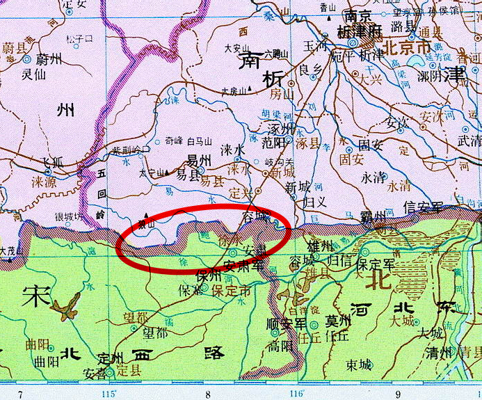
Map 1 - Boundary line between Khitan and Northern Song, 1111 AD.12 Area marked with red circle is the scope of search for Zimeng 紫蒙.
From Zhao 趙 , Shen 深 , and Hejian 河間 in the south, to Pingzhou 平州 in the north, Koushui 滱水13, Rushui 濡水14, Zhanshui 沾水15, and Yishui 易水, etc., race together eastward to the sea. 南自趙 深 河間以北至平州 如滱水 濡水 沾水 易水 䓁 皆東趋于海
Shucaishi Chuanpangtong 書蔡氏傳旁通16 book 2
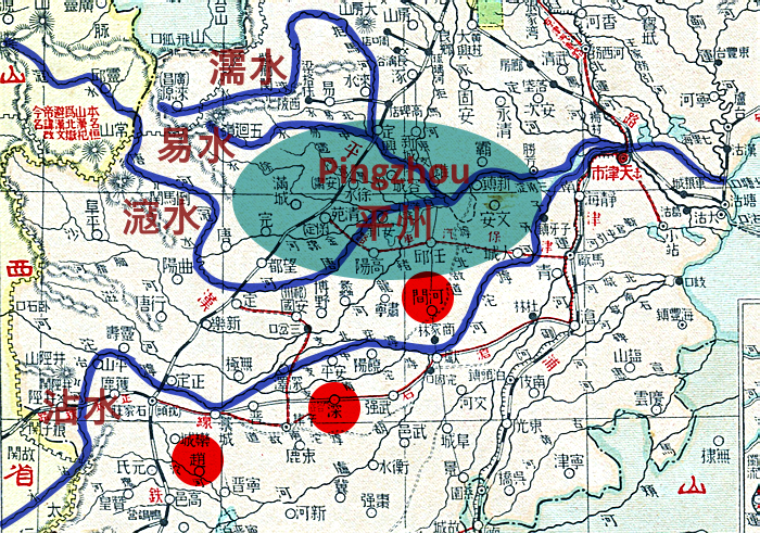
Map 2 - Pingzhou as it appears in Shucaishi Chuanpangtong 書蔡氏傳旁通. Zhanshui 沾水, Koushui 滱水, Yishui 易水, Rushui 濡水, and Zhao 趙, Shen 深, Hejian 河間 are visible.17
For reference, it is clear that Pingzhou 平州 as understood by Hu Sanxing 胡三省, broadly coincides with present day Baoding, which Pingzhou of Tang 唐 period also coincides with. The location of Pingzhou at the time when Hu Sanxing had lived is apparent, as per the record of Shucaishi Chuanpangtong 書蔡氏傳旁通. (refer to Map 2. For detailed discussion on the correct location of Pingzhou 平州 refer to ☞ https://earthlin9.tistory.com/17, article in Korean)
Parhae's Sangnak(常樂) has endured more than a thousand years
Rivers which flow in southeasterly direction through the present day districts of Xushui 徐水, Dingxing 定興, Mancheng 滿城, and Yixian 易縣 which coincide with the Khitan-Northern Song border region of Pingzhou, include Baohe 瀑河18, Xushui 徐水, Jizhuahe 鷄爪河, and Yishui 易水.
Murong Hui 慕容廆, courtesy name Yiluo Gui 弈洛瑰, is a Xianbei 鮮卑 person from Jicheng 棘城 of Changli 昌黎. His ancestors were descendants of Youxiong 有熊 clan. Throughout generations they resided in Northern Yi 北夷 and gathered in the plains of Zimeng 紫蒙, and were referred to as Donghu 東胡. 慕容廆 字弈洛瑰 昌黎棘城鮮卑人也 其先有熊氏之苗裔 世居北夷 邑於紫蒙之野 號曰東胡
Book of Jin 晉書 book 108
As per the above record from Book of Jin 晉書, Donghu 東胡 lived in the 'plains' of Zimeng 紫蒙, by which we learn that Zimeng was located within the expanse of broad plains. Accordingly, the source of Peishui 浿水 situated at Zimeng, must also have been in the middle of a flat-lying lowland. Among the possibilities for Peishui forementioned above Jizhuahe 鷄爪河 is the only river which originates from within a flatland area, the rest emerging from rugged mountains to the northwest of Baoding.
Jizhuahe 雞爪河 : It was called 'Fanshui 范水' in Li Daoyuan's Shuijingzhu 水經注. It originates from the Jizhua spring 雞爪泉 in the flatland northwest of Guchengzhen 固城鎮, Dingxing county 定興縣, passing through the counties of Dingxing, Xushui, Rongcheng, and Anxin. 雞爪河, 酈道元《水經注》稱范水, 雞爪泉平地涌水, 發源於定興縣固城鎮西北, 流經河北省保定市定興縣, 徐水縣, 容城縣, 安新縣。
Baidu encyclopaedia, '雞爪河'
Let us then track down the source of Jizhuahe.
Jizhuahe 鷄爪河 (chicken claw river) emerges from three separate locations in the southwestern part of Dingxing 定興 district, Baoding. It is named as such because its tributaries stretching from their sources and then merging into the main stream are similar in shape to a chicken claw. Now, the tributary of Jizhuahe positioned to the far northeast emerges from a village named, extraordinarily, 'Sangnakfucun 常樂富村'19.
Map of Sangnakfucun (i.e. Changlefucun) ☞ https://goo.gl/maps/QBmmqKc1wpc7tx3k8
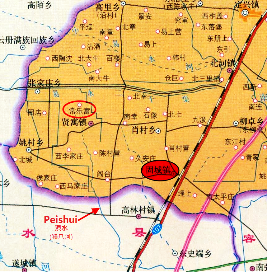
Map 3 - Jizhuahe originating from Sangnakfu (Changlefu) village.
Source of original map: ☞ http://map.ps123.net/china/5000.html
Liaoyang prefecture 遼陽縣 was originally Keumdok 金徳縣 prefecture region of Parhae 渤海 state. It was a Han(漢)'s Peishui prefecture 浿水縣, which Koryo (i.e. Koguryo) 髙麗 renamed to be Kuryo prefecture 勾麗縣. It became Sangnak prefecture 常樂縣 of Parhae 渤海. There were 1,500 households. 遼陽縣 本渤海國 金徳縣地 漢 浿水縣 髙麗改為勾麗縣 渤海為常樂縣 户一千五百
History of Liao 遼史 dilizhi 地理志, 'Dongjing Liaoyangfu 東京遼陽府'20
It is said in History of Liao 遼史 dilizhi 地理志 that the original Peishui prefecture 浿水縣 of Han 漢 was renamed by Koryo (i.e. Koguryo) 高麗 to Kuryo prefecture 勾麗縣, and then to Sangnak prefecture 常樂縣 by Parhae 渤海. Peishui 浿水 was located in Nangnang 樂浪 commandery of Han 漢. It was within the perimeter of Choson 朝鮮 today. Keumdok 金徳 and Sangnak 常樂, which are the names of a prefecture in Chunggyong Hyondokpu 中京顯徳府 of Parhae. All of those were not here (i.e. peninsula Choson). 遼志云 本漢浿水縣 高麗改為句麗縣 渤海為常樂縣 浿水在漢樂浪郡 今朝鮮界内 金徳常樂乃渤海中京顯徳府縣名 皆不在此
Qinding Shengjing Tongzhi 欽定盛京通志 book 10021
Xushen 許慎 said, "Peishui 浿水 emerges from Loufang prefecture 鏤方縣 and flows eastward into the sea." Some said that it emerged from Peishui prefecture 浿水縣. It is said in Shisan Zhouzhi 十三州志 that Peishui prefecture existed to the northeast of Nangnang 樂浪, and that Loufang prefecture existed to the east of the commandery, and that all (tributaries of Peishui) emerged from the (originating) prefectures and passed southward through Loufang prefecture. 許慎云 浿水出鏤方 東入海 一曰出浿水縣 十三州志曰 浿水縣在樂浪東北 鏤方縣在郡東 盖出其縣南逕鏤方也
Shuijingzhu 水經注 book 14, 'Peishui 浿水'
According to the records of History of Liao 遼史 dilizhi 地理志, Qinding Shengjing Tongzji 欽定盛京通志, and Yu Deuggong(유득공 柳得恭)'s Parhae Go 渤海考, etc., Sangnak prefecture 常樂縣 under the jurisdiction of Parhae(渤海)'s Chunggyong Hyondokpu 中京顯徳府 was in fact the former Peishui prefecture 浿水縣 of Han 漢 dynasty period. In other words, Sangnak prefecture 常樂縣 was the source of Peishui 浿水.
Moreover, Jizhuahe 鷄爪河 emerging from Sangnakfucun (i.e. Changlefucun) 常樂富村 flows in southeasterly direction to north of central Xushui 徐水 district and then continues on eastward. At the time of Han 漢 dynasty Bohai 渤海 sea extended deep into the land mass close to Xushui district.22 Thus, the course of Jizhuahe matches precisely the depiction given in Shuijing 水經, according to which Peishui 浿水 had flowed in southeasterly direction, and then eastward into the sea.
Therefore, we have found the absolute location for Peishui prefecture 浿水縣 of Han's Nangnang 樂浪 commandery at Sangnakfucun (i.e. Changlefucun) 常樂富村 of present day Dingxing 定興 district, Baoding. Further evidences supporting Jizhuahe 鷄爪河 as the true identity for Peishui 浿水 will be presented later in the article, but it is truly a remarkable discovery in that a place name from Parhae period, more than a thousand years ago, was located precisely at the source of Peishui 浿水, exactly as per the historical records.
Peishui 浿水 is, without doubt, present day Jizhuahe 鷄爪河.
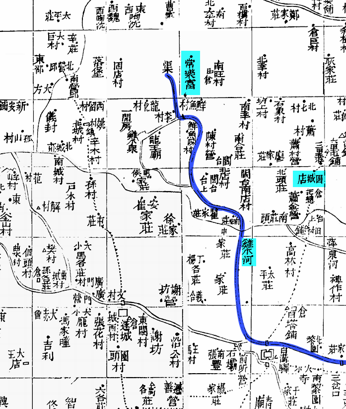
Map 4 - 'Jizhuahe 鷄爪河' and 'Sangnak 常樂' verified on an old map.23
In regard to the whereabouts of Loufang prefecture, by logically comparing the actual course of Jizhuahe 鷄爪河 against that of Peishui 浿水 as depicted in the records of Shisan zhouzhi 十三州志 we can deduce that the tributaries of Peishui (i.e. Jizhuahe) originating from the prefectures of Loufang 鏤方縣 and Peishui 浿水縣 merge within the bounds of Loufang, in other words, that the domain of Loufang prefecture was positioned to the south of Peishui prefecture. (refer to map 5)
Considering the facts discussed above, together with Hu Sanxing(胡三省)'s annotation to 'Zimeng 紫蒙' in Zizhi Tongjian 資治通鑑 book 214, indicating the proximity of Zimeng 紫蒙, and hence Loufang 鏤方, to Khitan-Northern Song boundary line, the location of Loufang prefecture can reliably be approximated and positioned at Xinmucun 辛木村 of Dingxing 定興 district where the southwestern most tributary of Jizhuahe 鷄爪河 originates and Khitan-Northern Song boundary line passes through in the immediate vicinity. (refer to map 5)
August, Buwiyom 扶尉厭 attacked Kuri fortress 九里城 and instated Kuryo prefecture 句麗縣 upon capturing it, and proceeded to invade Zimeng fortress 紫蒙城 [Kondo 昆都]. Sochon 西川, the king of Zimeng offered his wife Luhub 婁洽 in order to save his life. Buwiyom conjugated with Luhub and took her as his concubine. When Sochon reached again to offer Jagsol 雀舌 begging for his life, Buwiyom accepted her also, and pulled back his troops to Hohae 湖海 on the pledge of 2,000 heads of cattle and horses, 20 varieties of medicinal herbs, and 70 sheets of tiger skin as annual tributes, and offered to his king a Zimeng swine the size of a cow together with Luhub and Jagsol. 八月, 扶尉厭伐九里城拔之置句麗縣入紫蒙城[昆都]. 紫蒙王西川以其妻婁洽乞命, 尉厭遂通婁洽而妾之, 西川又以其雀舌来乞命. 尉厭亦取之, 約歲貢牛馬二千匹‧薬草二十種‧虎皮七十張而退軍湖海, 献紫蒙豕大如牛者及婁洽‧雀舌.
Chumogyong 芻牟鏡 (Posthumous work by Namdang 南堂遺稿) 下 book 6, 16th year of reign by King Dongmyong 동명성왕 (22 BC)
Further, there is a record in the version of Chumogyong 芻牟鏡 hand-written by Namdang Park Changhwa 남당 박창화, of Buwiyom 扶尉厭, a general of Koguryo king Dongmyong 동명성왕, who instates Kuryo prefecture 句麗縣 after the seizure of Kuri fortress 九里城, before heading to Zimeng fortress 紫蒙城 to exact its submission by force. Given the circumstances, Zimeng fortress (same location as Loufang prefecture) must have been situated close to Kuri fortress (same location as Peishui prefecture), in view of which this writer's comparative positionings of the fortresses at present-day Xinmucun 辛木村 and Changlefucun 常樂富村 respectively of Dingxing 定興 district, correspond with the record from Chumogyong.
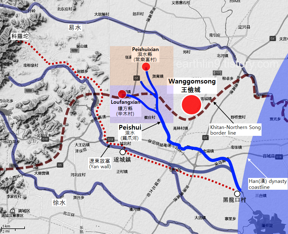
Map 5 - Peishui, Peishui prefecture, Loufang prefecture, Wanggomsong, and Yan wall are shown.24
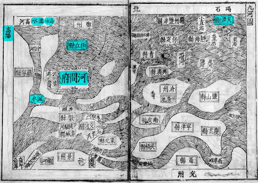
Map 5-1 - Bohai bay 渤海灣 region depicted on 'Juhetu 九河圖, book 1 of Jiajing Hejianfuzhi 嘉靖河間府志, 1540', present-day city of Tianjin 天津 is marked far offshore, with Hejian 河間 and Renqiu 任丘 also under the sea. The district of Gaoyang 高陽 near Baoding 保定, Hebei 河北, was on the Bohai coast according to Juhetu.
Old wall of Liaodong meets Peishui
Man 滿, the Choson 朝鮮 king was formerly from Yan 燕. In its heyday, Yan invaded Zhenfan 眞番 and Choson 朝鮮, and subdued them for the first time. (Yan) kept administrative official and built a defensive wall. With the annihilation of Yan by Qin 秦 it became a part of the frontier region of outer Liaodong 遼東. Han 漢, upon its rise, repaired the 'old wall at Liaodong 遼東故塞' and restored it to where it had reached Peishui 浿水, and set it as the boundary, keeping the territory under Yan, as it was too far, and hence difficult (for Han) to retain. 朝鮮王滿者 故燕人也 自始全燕時 嘗略屬眞番 朝鮮 爲置吏 築鄣塞 秦滅燕 屬遼東外徼 漢興 爲其遠難守 復修遼東故塞至浿水 爲界 屬燕
Shiji 史記 Choson Liezhuan 朝鮮列傳
According to the above records from Choson Liezhuan 朝鮮列傳 of Shiji 史記 the 'old wall of Liaodong 遼東故塞', which ran along the boundary between Old Choson 古朝鮮 and Han 漢, abutted Peishui 浿水. If it is true as per this writer's argument, that present day Jizhuahe 鷄爪河 is in fact the ancient Peishui, then the 'old wall of Liaodong' must run into, or come very close to Peishui at some stage of its course.
Southern wall25 of Yan 燕 starts at its western end at peak number 2 of Keluotou 科羅頭 (i.e. 科羅坨) situated to the west of Renyizhuang 仁義庄 on the western periphery of Yixian 易縣 district, Hebei. Upon entering Taihezhuang 太和庄 of Xushui 徐水 district via Quchengcun 曲城村 at the eastern boundary of Yixian 易縣, it passes by Jiecun 解村 before reaching the gates of Xushui fortress. It continues on eastward, passing by Shangpingzhuang 商平庄 to reach Heilongkucun 黑龍口村 of Rongcheng 容城 district. 燕國南長城西起今河北易縣西境仁義庄西科羅頭的第二個山峰上 向東至易縣東境曲城村入徐水縣太和庄 經徐水解村至徐水縣城關 再往東經商平庄至容城縣黑龍口村
Yan culture 燕文化, Chen Ping 陳平 2006, p168
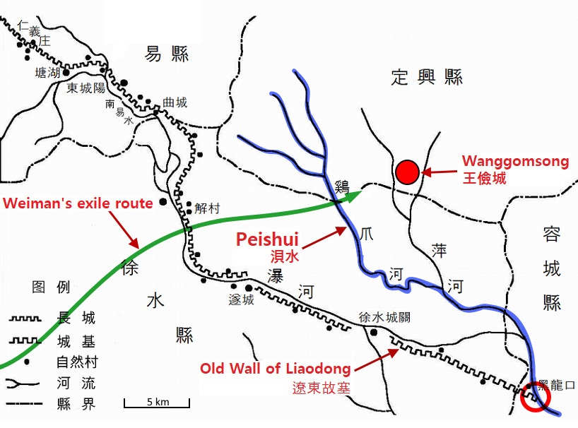
The Yan 燕 wall which starts at Keluotou 科羅頭 peak number 2 at the northeastern end of Mt. Langya 狼牙山, Baoding 保定 and extends in the southeasterly direction, passing through Xushui 徐水 district, may in fact be the 'old wall of Liaodong 遼東故塞' mentioned in Shiji 史記.26 As clarified in Yan culture 燕文化 the Yan wall continues on from Xushui to reach Heilongkucun 黑龍口村, a riverside village by Jizhuahe 鷄爪河. In other words, the Yan wall runs into Jizhuahe, corresponding precisely with the historical records of Shiji which state that the 'old wall of Liaodong' had reached Peishui 浿水. (refer to map 5 and 6)
Map 6 - 'Old wall of Liaodong 遼東故塞' abutting Peishui (marked with red circle).27
As Lu Wan 盧綰 the Yan 燕 king defected after betraying (Han 漢), Man 滿 gathered a thousand people and went into exile, escaping to the east, dressed like an outlander28 with a rough topknot. Through the wall (of Liaodong 遼東) and beyond Peishui 浿水, he had settled in the old, vacant land of Qin 秦, namely the upper and lower bastions.29 燕王盧綰反 入匈奴 滿亡命 聚黨千餘人 魋結蠻夷服而東走出塞 渡浿水 居秦故空地上下鄣
Shiji 史記 Choson Liezhuan 朝鮮列傳
Guangyang state 廣陽國 was Yan state 燕國 at the time of Gaodi 髙帝30. In the first year of Yuanfeng 元鳳31 during the reign of Zhaodi 昭帝 it became Guangyangjun 廣陽郡. In the first year of Benshi 本始32 during the reign of Xuandi 宣帝 it was changed to a state 國. It consists of 20,704 households and 70,658 residents across 4 prefectures. Ji 薊 is where Duke of Shao 召公 had been appointed as a feudal lord. Wangmang 莽曰 called it Farong 伐戎. .... 廣陽國 髙帝燕國 昭帝元鳳元年為廣陽郡 宣帝本始元年更為國 莽曰廣有 戸二萬七百四十 口七萬六百五十八 縣四 薊 故燕國 召公所封 莽曰伐戎 ....
Book of Han 前漢書 book 28 下 dilizhi 地理志
Ji 薊 was the capital of the old Yan 燕. Zhaodi 昭帝 renamed it to Guangyang state 廣陽國, the capital of which was also Ji 薊. 薊 故燕都 昭帝改燕為廣陽國 亦治薊
Zizhi Tongjian 資治通鑑 book 39, annotation by Hu Sanxing 胡三省
Also, observed with Peishui 浿水 placed at the location of Jizhuahe 鷄爪河, the exile route that Weiman 衛滿 and his group of 1,000 followers took upon their escape from Yan state 燕國 destined for Old Choson 古朝鮮, becomes apparent. In other words, considering the location of Ji prefecture 薊縣 of Yan state, which is comparatively determined to be present day Tang 唐 district of Baoding (refer to ☞ https://earthlin9.tistory.com/20 and ☞ https://earthlin9.tistory.com/32, articles in Korean, for the location of Ji prefecture 薊縣 of post-Qin秦 Yan 燕), it is clear that Weiman and his group began the journey at Tang district (Ji prefecture 薊縣), arriving at an area in the vicinity of Jiecun 解村 in Xushui 徐水 via Wan 完 (i.e. Shunping 順平) and Mancheng 滿城 districts, where they entered the territory of Old Choson by passing through the Yan wall (塞), before crossing Jizhuahe (Peishui), to ultimately reach Guchengzhen 固城鎮 (upper and lower bastions 上下鄣) of Dingxing 定興 district. Weiman's exile route as elucidated above fits precisely the depiction given in Shiji 史記. (refer to Maps 6 and 6-1)
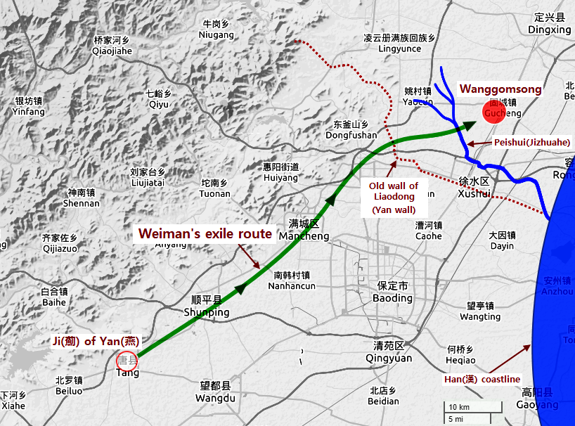
Map 6-1 - Weiman's exile route
The old fortress of Fanyang 范陽故城 was (at) Fanyang prefecture 范陽縣 of Qin 秦. It exists to the north of Fanshui river 范水, 62 li 里 southeast of (Yixian 易縣) prefecture. 范陽故城秦范陽縣也 縣東南六十二里 以在范水之陽
Yuanhe Junxianzhi 元和郡縣志 book 22, 'Yixian 易縣'
Further, it is recorded in Yuanhe Junxianzhi 元和郡縣志 that area around the old fortress of Fanyang 范陽故城 the ruins of which exist at present day Guchengzhen 固城鎮 of Dingxing 定興 district, was Fanyang prefecture 范陽縣 of Qin 秦. This fact corresponds appropriately with the record in Shiji 史記 'Choson Liezhuan 朝鮮列傳' which informs that upper and lower bastions 上下鄣 where Weiman 衛滿 and his followers had settled upon the exile, was an old, vacant land of Qin 秦.
Jizhuahe(鷄爪河) is Nihe(泥河)
Peishui 浿水 exists along with Puhe 蒲河 and Qinghe 清河. Peishui is also called Nihe 泥河, or Hanurak 蓒芋濼 because a lot of taro plants grow along the river. 有蒲河 清河 浿水 亦曰 泥河 又曰 蓒芋濼 水多蓒芋之草
History of Liao 遼史 dilizhi 地理志, 'Dongjing Liaoyangfu 東京遼陽府'
We learn through the above record from History of Liao 遼史 dilizhi 地理志 that the ancient river of Peishui 浿水 had also been referred to as 'Nihe 泥河'.
Dongjing Liaoyangfu 東京遼陽府 was originally the land of Choson 朝鮮. Upon his release from jail by King Wu of Zhou 周武王, Jizi 箕子 went to Choson 朝鮮 where he was appointed as a feudal lord. .... At the time of early Han 漢 Man 滿, a man of Yan 燕, became the king at the old vacant land. In the third year of Yuanfeng 元封, Wudi 武帝 suppressed Choson 朝鮮 and set up the four commanderies of Chinbon 真番, Imdun 臨屯, Nangnang (Lelang) 樂浪, and Hyondo 玄菟. 東京遼陽府 本 朝鮮之地 周武王釋 箕子囚 去之朝鮮 因以封之 .... 漢初 燕人滿王故空地 武帝元封三年 定朝鮮 為 真番 臨屯 樂浪 玄菟 四郡
History of Liao 遼史 dilizhi 地理志, 'Dongjing Liaoyangfu 東京遼陽府'
Dongjing Liaoyangfu 東京遼陽府 of Liao 遼 state was originally the land of Choson 朝鮮 where Weiman 衛滿 became the king, prior to being subjugated by Wudi 武帝 of Han 漢, who established the four commanderies there. Therefore, Peishui 浿水 which according to the records had existed within Dongjing Liaoyangfu 東京遼陽府 is without doubt the Peishui 浿水 in question, which is associated with Wanggomsong 王儉城.
But surprisingly, Jizhuahe 鷄爪河 which this writer argues to be the real Peishui 浿水, was called Nishui 泥水 in the ancient times.
Whilst Yishui 易水 continues on eastward, Nishui 埿水 flows into it. The river (i.e. Yishui), starting from the top (i.e. north) interconnects the two swamplands to the southeast of Rongcheng prefecture 容城縣, namely Danidian 大埿淀 and Xiaonidian 小埿淀. Where the river (i.e. Nishui) flows southward into Yishui, is called Nidongkou 埿洞口. Right next to the river is Hunni fortress 渾埿城, to the south of which Yishui passes eastward before it joins Koushui 滱水. 易水又東 埿水注之 水上承二陂于容城縣東南 謂之大埿淀 小埿淀 其水南流注易水 謂之埿洞口 水側有渾埿城 易水逕其南 東合滱水33
Shuijingzhu 水經注 book 11, 'Yishui 易水'
Nanyishui 南易水 exists to the south of the prefecture (i.e. Rongcheng 容城). It flows across the boundary into Gaoyang prefecture 高陽縣 of Yingzhou 瀛州, and joins Koushui 滱水. Abadoned fortress of the prefecture exists 50li (里) to the northwest of the 'zhou 州' (i.e. Xiongzhou 雄州). Danidian 大埿淀 lies 30li to the south of the prefecture (i.e. Rongcheng). An annotation to Shuijing 水經 said that where Yishui flows eastward into Danidian of Rongcheng, is called Nitongkou 泥同口. 南易水在縣南 流入瀛州高陽縣界 與滱水合流 廢縣城在州西北五十里 大泥淀在縣南三十里 注水經云 易水東流容城 大泥淀注之 泥同口之謂也
Taiping Huanyuji 太平寰宇記 book 67, 'Xiongzhou 雄州', 'Rongcheng prefecture 容城縣'
According to the above records from Shuijingzhu 水經注 and Taiping Huanyuji 太平寰宇記, a river named Nishui 泥水 flowed southward to join Nanyishui (南易水, i.e. Baohe 瀑河), before flowing into Danidian 大泥淀 and Xiaonidian 小泥淀 to the southeast of Rongcheng prefecture 容城縣.34 Danidian and Xiaonidian are clearly the ancient names for what now are the swamplands of Baiyangdian 白洋淀 which lie to the southeast of Xushui 徐水區 and Rongcheng 容城縣 districts, Baoding 保定. And Nanyishui still exists today unchanged35, with the same name. Therefore, the river which flowed southward to join Nanyishui, and then into Baiyangdian is, without doubt, present day Jizhuahe.36 (refer to map 7) This is yet another strong evidence proving that Jizhuahe is in fact the ancient Peishui.
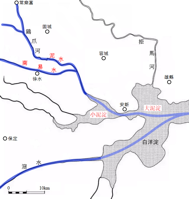
Map 7 - Nishui 泥水 joining Nanyishui 南易水
Ruins of Wanggom and Pyongyang fortresses at Gucheng, Dingxing
At Guchengzhen 固城鎮 of Dingxing 定興 district, Baoding 保定, there remain ruins of ancient fortress known as Gucheng 固城 or Fanyang Gucheng 範陽古城.
Satellite map of Gucheng ☞ https://satellites.pro/China_map#E39.133408,115.694891,17
As can be seen on the satellite map, even though the site has been almost completely overrun by residential quarters, etc., outlines of the fortress, marked by what appear to be fallen walls are recognizable, and several pools of water seen around the site are probably the remnants of moat.
Guchengzhen 固城鎮 belongs to Dingxing 定興 district of the city of Baoding 保定. It is a 'zhen 鎮' under the jurisdiction of Dingxing district, the city of Baoding. In the old days north of a river used to be designated as 'Yang 陽'. 'Fanyang 范陽' was so named because the fortress was positioned to the north of Fanshui 范水. (Fanshui: namely the present day Jizhuahe 雞爪河 of Guchengzhen, Dingxing district) 固城鎮隸屬於河北省保定市定興縣 是河北省保定市定興縣轄鎮,古時稱南水北為陽,城在范水之北而得名范陽 (范水:即今定興縣固城鎮雞爪河)
Baidu encyclopaedia, '固城鎮'
Xiandu 險瀆 of Liaodongjun 遼東郡: Ying Shao 應劭 said King Man 滿 of Choson 朝鮮 had established the capital there. It was named Xiandu 險瀆 because it relied on choppy waters. Chen Zan 臣瓉 said "Wanghomsong (i.e. Wanggomsong) 王險城 existed to the east of Peishui 浿水. Xiandu is just Xiandu." Shi Gu 師古 said that Chen Zan is correct. Pronounciation of 浿 is 'Pae' (普大反). 遼東郡 險瀆, 應劭曰 朝鮮王滿都也 依水險 故曰險瀆 臣瓉曰 王險城在樂浪郡浿水之東 此自是險瀆也 師古曰 瓚説是也 浿音普大反
Book of Han 前漢書 book 28 下 dilizhi 地理志
The location of Gucheng 固城, situated 7km to the east of Jizhuahe 鷄爪河, coincides exactly with the testimony of Chen Zan 臣瓉 who stated that Wanggomsong 王儉城 had existed to the east of Peishui 浿水. (refer to map 5) Interestingly also, the subtle meaning 'persistent fortress' or 'stubborn fortress', of 'Gucheng 固城' probably alludes to the defiance of Choson 朝鮮 King Ugo 우거 右渠 of Wanggomsong and his minister Songgi 성기 成己 who fought to the end against Han 漢 invasion. In fact, Sima Qian 司馬遷 wrote in Shiji 史記, "While relying on his stubbornness Ugo lost the state. 右渠負固, 國以絶祀". Further, Gucheng is situated not far to the southeast of Sangnakfu (i.e. Changlefu) 常樂富 village which has been revealed to be Peishui prefecture 浿水縣 of Han 漢, and later Sangnak prefecture 常樂縣 under Parhae(渤海)'s Chunggyong Hyondokpu 中京顯徳府. It is apparent that in addition to having been Wanggomsong of Old Choson, Gucheng was also the capital of Parhae's Chunggyong Hyondokpu.
Kuodezhi 括地志 said "Koryo (i.e. Koguryo) 高驪 set up its capital at Pyongyangsong 平壤城, originally Wanghomsong (i.e. Wanggomsong) 王險城 of Han(漢)'s Nangnang 樂浪 commandery. It had also been said to be the land of Choson 朝鮮 from old times. 括地志云 高驪都平壤城 本漢樂浪郡王險城 又古云朝鮮地也
Shiji 史記 Choson Liezhuan 朝鮮列傳, annotation of Zhengyi 正義
Hyondokpu 顯德府 was originally a land of Choson 朝鮮, namely Pyongyangsong 平壤城. King Wu of Zhou 周武王 had appointed Jizi 箕子 as a feudal lord. It was the base for Gongsun Du 公孫度 in late Han 漢, and then was occupied by Koguryo 高句麗 at the time of Jin 晉. Tang 唐 set up Andong Douhu 安東都護 there, which Dae 大 clan took possession of. It was named Holhanju 忽汗州 at the time of Zhong zong 中宗. 顯德府 本朝鮮之地 卽平壤城 周武王以封箕子 漢末爲公孫度所據 晉時陷於高句麗 唐置安東都護 爲大氏所有 中宗時賜名忽汗州
Parhae Go 渤海考
Taiwu 太武 of Yuan Wei 元魏 had dispatched an envoy to their (i.e. Koguryo's) residence at Pyongyangsong 平壤城. Dongjing 東京 of Liao 遼 was there originally. Gaozong 髙宗 of Tang 唐 set up Andong Douhufu 安東都䕶府 there upon subduing Koryo (i.e. Koguryo) 髙麗. The Dae 大 clan of Parhae 渤海 later took possession of it. .... Holhanju 輝罕州 (i.e. 忽汗州) is namely the old Pyongyangsong, which had been called Chunggyong Hyondokpu 中京顯徳府. 元魏 太武遣 使 至其所居平壤城 遼 東京 本此 唐髙宗 平 髙麗 於此 置 安東都䕶府 後為 渤海大氏所有 .... 輝罕州即 故 平壤城也 號 中京顯徳府
History of Liao 遼史 dilizhi 地理志, 'Dongjing Liaoyangfu 東京遼陽府'37
It also becomes clear through the above records of annotaion in Shiji 史記 Choson Liezhuan 朝鮮列傳, Parhae Go 渤海考, and History of Liao 遼史 dilizhi 地理志, that Chunggyong Hyondokpu 中京顯徳府 of Parhae 渤海 was in fact formerly Wanggomsong 王儉城 of Old Choson 古朝鮮.
The Great Andong Douhufu 安東大都護府 : Shun 舜 split up Qingzhou 靑州 to create Yingzhou 營州, and set up a mu 牧. Obviously it is to the east of Liaoshui 遼水. During both the Spring and Autumn 春秋 and the Warring States 戰國 periods it had belonged to Yan 燕, and during Qin 秦 and the two Han 漢 periods it was called Liaodongjun 遼東郡 and was linked to Nangnang 樂浪 to the east. Jin 晉 inherited it and set up Pingzhou 平州 along with it. At the time of Later Wei 後魏 Koryo (i.e. Koguryo) 高麗 set up its capital at that location. 安東大都護府, 舜分靑州爲營州 置牧 宜遼水之東是也 春秋及戰國 竝屬燕 秦二漢曰遼東郡 東通樂浪 晉因之 兼置平州 後魏時 高麗國都其地
Tongdian 通典 book 180, 'Zhoujun 州郡'38
Jin 晉 set up Pingzhou 平州. At the time of Later Wei 後魏 the state of Koryo (i.e. Koguryo) 高麗 set up its capital at the location, before Tang 唐 set up Andong Douhufu 安東都護府 there. 晉置平州 後魏時 高麗國都其地 唐置安東都護府
Tongjian dili tongshi 通鑑地理通釋 book 10
Especially, according to the above records of Tongdian 通典 and Tongjian dili tongshi 通鑑地理通釋, the capital of Koguryo 高句麗, at the time of Northern Wei 北魏39, was at the same location where Pingzhou 平州 of Jin 晉 had been situated previously. The Koguryo capital indicated in these records is in fact Pyongyangsong 平襄城 where the envoy of Northern Wei had been dispatched to by Taiwudi 太武帝, that is, Pyongyangsong, the new capital of Koguryo, established in 427 AD during the reign of King Jangsu 長壽王. To sum up, we learn that Wanggomsong 王儉城 of Old Choson 古朝鮮 had later become Pyongyangsong of Koguryo, which in turn had become the Chunggyong Hyondokpu 中京顯德府 of Parhae 渤海, all exactly at the same location. Traces left by the Korean capitals remain in the ruins of Gucheng 固城 at Dingxing 定興 district.
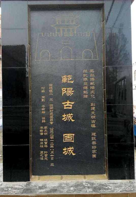
Gucheng stele at Guchengzhen, Dingxing district
Chong Pyong 淸平40 said "The land of Parhae(渤海)'s Chunggyong Hyondokpu 中京顯德府, to the north of Sokmal river 粟末水, is Imgeumsong 壬儉城 where Tangun 檀君 first established the first capital, i.e. Pyongyang 平壤. 淸平云 粟末水之陽有渤海中京顯德府地 此乃檀君始都處 故壬儉城 卽平壤也
Kyuwon Sahwa 揆園史話 Tangungi 檀君紀
Moreover, provided that the above record of Chinyok Yugi 震域遺記 is accurate, the area surrounding Gucheng 固城 is the first capital of Tangun Choson 檀君朝鮮.
Pyongyang was 60 li from the mouth of Peishui
(Lai 來) Huer 護兒 led a fleet of louchuan 樓船 ships into the war at Liaodong 遼東, and directed them across Canghai 滄海 to infiltrate into Peishui 浿水. The distance to Pyongyang 平壤 was 60 li 里. 遼東之役 護兒率樓船 指滄海 入自浿水 去平壤六十里
Book of Sui 隋書 book 64, 'Laihuer 來護兒'
Laihuer 來護兒 the first vice admiral, led an armada of Jianghuai 江淮 naval forces spanning several hundred li 里 of the sea to infiltrate ahead into Peishui 浿水. The distance to Pyongyang 平壤 was 60 li 里. 左翊衛大將軍來護兒 帥江淮水軍 舳艫數百里 浮海先進入自浿水 去平壤六十里
Chronicles of the Three States 三國史記 book 20, Basic Annals of Koguryo 高句麗本紀 'King Yongyang 嬰陽王'
According to the above records of Book of Sui 隋書 and Chronicles of the Three States 三國史記, the Sui 隋 armada proceeded to Pyongyang 平壤 by entering Peishui 浿水 from Bohai sea 渤海 at the time of Sui 隋 invasion of Koguryo 高句麗 by the emperor Yang 煬帝 in the 23rd year of reign of King Yongyang 嬰陽王 of Koguryo (612 AD). We also learn from the records that the Pyongyang was 60 li 里 in distance from the mouth of Peishui.
Based on the name 'Heilongku 黑龍口' of the township, which imply 'mouth of a river', in addition to the fact that Heilongku is situated not far from the swamplands of Baiyangdian 白洋淀 which would have been a part of Bohai sea 渤海 in the ancient times, it would seem apparent that present day Heilongku had been at the mouth of Jizhuahe 鷄爪河 on the ancient shore of Bohai sea. If Jizhuahe is in fact the ancient Peishui 浿水 as per the argument put forward by this writer, then the naval forces of Sui 隋 must have retraced the course of the lower reaches of Jizhuahe, starting from the mouth in the vicinity of Heilongku, and then followed the route along the tributary of Pinghe 萍河 in order to reach Gucheng 固城, the ancient fortress of Pyongyang 平壤. (refer to map 8)
But, the the route to reach Gucheng 固城 from Heilongku 黑龍口 via the courses of Jizhuahe 鷄爪河 and its tributary of Pinghe 萍河 respectively, is approximately 26 kilometres in length. Based on '大尺 large chi (0.2955 metre)' used at the time of Tang 唐 dynasty when Book of Sui 隋書 was being written, the Chinese unit of distance 'li 里' represented either 1,500 大尺 (443.25 metres) or 1,800 大尺 (531.90 metres).41 Applying 1,500 大尺 as 1 li, the distance between Heilongku and Gucheng is determined to be 58.7 li 里. Oddly enough, this practically coincides precisely with the historical records.
The argument above further supports the view that present day Jizhuahe 鷄爪河 is in fact the ancient Peishui 浿水, and additionally that Pyongyang fortress 平壤城 of Koguryo 高句麗 had been situated at Gucheng 固城.
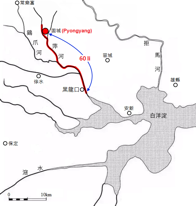
Map 8 - The distance between mouth of Peishui and Pyongyang fortress
Fanshui is Hanurak
Jizhuahe 鷄爪河 which has been identified in this article as Peishui 浿水 appears many times in historical texts as Fanshui(範水 or 范水 simplified). The ancient place name, Fanyang 範陽, also originated from its literal meaning, namely 'north of Fanshui'.
Peishui 浿水 exists along with Puhe 蒲河 and Qinghe 清河. Peishui is also called Nihe 泥河, or Hanurak 蓒芋濼42 because a lot of taro43 plants grow along the river. 有蒲河 清河 浿水 亦曰 泥河 又曰 蓒芋濼 水多蓒芋之草
History of Liao 遼史 dilizhi 地理志, 'Dongjing Liaoyangfu 東京遼陽府'
Further, according to the above record from History of Liao 遼史 dilizhi 地理志, Peishui 浿水 was also known as 'Hanurak', but what's more intriguing is the fact that the characters 'fan 範' of Fanshui(範水) and 'han 蓒' of Hanurak(蓒芋濼) look very much similar in shape. Would it be just a coincidence?
This writer dare say not.
Firstly, '範' and '蓒' are related in that '范', the simplified form of the character '範', has 'plant' among its meanings, and that '蓒芋' indicates taro44 plant. (refer to ☞ https://earthlin9.tistory.com/18, article in Korean)
範 蓒
fan 範 is sang 常45. 範, 常也
Kangxi dictionary 康熙字典 '範'
fan 範 imitated in shape, is sang 常. 範者, 模法之常也
Erya Zhushu 爾雅注疏 book 1
Further, it is said in Kangxi dictionary 康熙字典 that 'fan 範' is 'sang 常', and in the record of Erya Zhushu 爾雅注疏, as quoted by Kangxi dictionary, that 'sang 常' is an imitation in shape of 'fan 範'. It is, therefore, highly probable that these clues overall indicate that 'Fanshui 範水' and 'Sangnak 常樂' are in fact alternative expressions of 'Hanurak 蓒芋濼', with the same meaning, namely 'taro river'. In other words, if Fanshui is in fact Sangnak, and in turn Hanurak, then Fanshui is at the same time Peishui 浿水. (We also realize that Sangnak prefecture 常樂縣 and Peishui prefecture 浿水縣 are place names with the same implication.) This is a striking fact which provides us with a way of cross examination, aside from geographical place name searches, reaffirming that Jizhuahe 鷄爪河 is in fact Peishui.
Conclusion
A critical clue resulting from the discovery of an annotation verse to Zizhi Tongjian 資治通鑑 by Hu Sanxing 胡三省, enabled this writer to locate the absolute position of Peishui prefecture 浿水縣 affiliated with Han(漢)'s Nangnang 樂浪 commandery, along with reliable determination of the location for Loufang prefecture 鏤方縣, which in turn lead to the identification Peishui 浿水 and Wanggomsong 王儉城 without much difficulty. Also, Wanggomsong of Old Choson 古朝鮮, Pyongyangsong 平壤城 of Koguryo 高句麗, and the centre of Parhae(渤海)'s Chunggyong Hyondokpu 中京顯德府 were all found to had been located respectively at the same place, namely the ruins of Gucheng 固城 at Dingxing 定興 district of Baoding. Furthermore, the newly revealed identity of Peishui was cross-validated using several historical sources separate from the record by Hu Sanxing.
The precise locations for the key place names investigated in this article are as follows.
Wanggomsong 王儉城 of Old Choson 古朝鮮: area around Guchengzhen, Dingxing discrict, Baoding Hebei (河北省 保定市 定興縣 固城鎮)
Pyongyangsong 平壤城 of Koguryo 高句麗: area around Guchengzhen, Dingxing discrict, Baoding Hebei (河北省 保定市 定興縣 固城鎮)
Chunggyong Hyondokpu 中京顯德府 of Parhae(渤海): area around Guchengzhen, Dingxing discrict, Baoding Hebei (河北省 保定市 定興縣 固城鎮)
Peishui 浿水: Jizhuahe within the districts of Dingxing and Xushui, baoding Hebei (河北省 保定市 定興縣-徐水區 鷄爪河)
Peishui prefecture 浿水縣 of Han(漢)'s Nanglang (Lelang) 樂浪 commandery: area around Changlefucun, Dingxing district, Baoding Hebei (河北省 保定市 定興縣 常樂富村)
Loufang prefecture 鏤方縣 of Han(漢)'s Nanglag (Lelang) 樂浪 commandery: area around Xinmucun, Dingxing district, Baoding Hebei (河北省 保定市 定興縣 辛木村)
Article written by earthlin9 @ https://earthlin9.tistory.com
Korean language version of this article is available at
☞ 고조선의 왕검성과 고구려 평양성의 위치는 하북성 보정시 정흥현의 고성이다. 낙랑군 패수현의 정확한 위치 발견